LandPrint.com Creates New Market for 3D Printing with 3D Physical Landscapes
Virtually any kind of 3D data can be added to the geographic model to make a 3D print.


Latest News
April 10, 2008
By Susan Smith
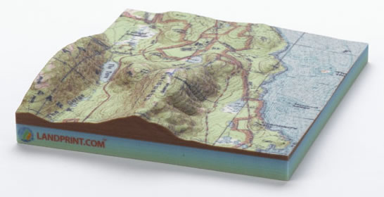
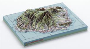 Where consumers have enjoyed finding their homes or charting the course of their vacations or other adventures on Google Earth, with LandPrint.com they can now own a 3D model of any landscape on the planet. The information they might normally input into Google Earth, can be output to a 3D printer, according to Z Corporation vice president of business development, Scott Harmon. These models are 3D-printed in full color by Z Corporation (Burlington, MA) and shipped directly to the customer’s door.
The author of NASA’s World Wind, an open source virtual globe, Tom Gaskins, CEO of the recently formed Redmond, WA-based LandPrint.com, became aware of 3D printing while he was developing World Wind. At the time, he thought it might be a good idea to take a Google Earth type interface like World Wind, and use it to put 3D data such as vegetation, planning, and real estate data onto a 3D print. Gaskins spent a year compiling data for his LandPrint.com website to make it successful to a broad, nontechnical, and technical audience.
“Together with Z Corporation, we’re taking raw geospatial data and turning it into something people can savor and understand at a much deeper level. Z Corporation 3D printers offer a superior blend of speed, color, resolution, and affordability, so they were the obvious — rather, the only — choice for us,” said Gaskins in a recent press release.
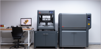
For Z Corporation, this is one of its first explorations into printing services. As the makers of 3D printers that can print quickly in multiple colors, the company takes 3D printing to a new level by “ZPrinting” LandPrint.com landscape models using an inkjet system to bind together ultrathin layers of composite powder.
Although LandPrint.com is currently geared toward the consumer and the “fun user” such as marathoners and adventure racers, Gaskins sees a bigger marketplace out there. Virtually any kind of 3D data can be added to the model to make a 3D print, creating a geographical print for anything from real estate to schools to city planning to land development.
“We’ve gotten some positive feedback from people who are already selling maps today, such as National Geographic.com and Maps.com, that have large GIS or geography-oriented web presences,” said Harmon. “We think there will be other communities that will evolve around specific usages for the prints. One of our buyers who has a vacation rental home in Vermont is planning to give those who come to stay at the home a 3D print of the terrain as a gift. People who are hiking, adventure traveling, or racing will be able to annotate the terrain maps. If you’re on a long hike and you want to show various camps you stopped at, all that will be possible soon. We see it as a split between commemorative / entertainment uses, and also education uses.”
As a teaching tool, LandPrint.com could be valuable for teaching students about geography and terrain.
Harmon said Z Corp’s 3D printers are used extensively by architects. “We do envision that you’ll be able to layer your own datasets and my impression is that the dataset that’s in there right now is not well suited to what architects would want. I think they’ll want more detailed data. Part of the development of LandPrint.com will be the ability to lay in custom data sets and to generate 3D prints of those.” Harmon added that eventually there may be the opportunity to add building data so people could print city blocks.
Gaskins envisions the eventual addition of more text waypoints and satellite or other imagery, as well as 3D building models. On the consumer side, he said, “You can imagine for some of these major tours or races that cover significant amounts of terrain, like the Western States 100, a 3D print could be a trophy.”
 “On the commercial side we have a lot of people who want to look at their own imagery and own data, particularly elevation data in the form of either digital elevation models or some other LiDAR derived form,” noted Gaskins. “What we plan to do for those customers is to make it easy for them to include their imagery or shapefiles on a terrain model as well as specify their own terrain data as well. We have the software to do that, yet haven’t exposed the interface for that yet. We’re still working out the details of the implementation and the interface. Getting the interface right on this stuff is proving a challenge, because it has to be simple enough yet rich enough for a whole range of people to use.”
Another point is that currently, not many people own or have access to 3D printers. 3D printers are expensive and are generally found in larger manufacturing firms, some architectural firms, a few government agencies, and service bureaus. The USGS and NOAA have 3D printers. Service bureaus’ business generally comes from manufacturing firms as 3D printing has to date been the province of manufacturing.
“Just like the consumer or commercial vendor can use the Internet to create a model using our software and print it through Z Corp, we are providing our software to them virtually so they can print the model to their own machines,” said Gaskins.
Gaskins, a former NASA employee, said that NASA doesn’t have 3D printers, however, half their work involves earth science. “They have a lot of reasons to display their earth science data and they are not accustomed yet to using 3D models for that.”
Currently all the data LandPrint.com prints is in the public domain, such as digital terrain data from USGS and NASA, but Gaskins is talking to potential partners about being able to use their data through LandPrint.com. Several possibilities abound for this software-licensing model for a limited number of models per year. LandPrint.com can license the software for others, such as service bureaus, geographic related organizations with their own stores, etc. to use. LandPrint.com could provide the backend web services for storefronts so they don’t have to create the software themselves.
LandPrint.com will offer customization services, in addition to the customization customers are able to do on their own. Customers can upload their own imagery or GPS data, and LandPrint.com can georeference it for them.
Landprint.com
Redmond, WA
landprint.com
Z Corporation
Burlington, MA
zcorp.com
Subscribe to our FREE magazine, FREE email newsletters or both!
Latest News
About the Author
DE’s editors contribute news and new product announcements to Digital Engineering.
Press releases may be sent to them via [email protected].